Tropical System Will Impact Northern Gulf Next Week
Tropical Depression 19, which just kind of popped up in the Bahamas earlier this week is about to pop into the Gulf of Mexico. The system is currently moving westward over the southern tip of Florida. It is forecast to become a tropical storm sometime today.
The system's most likely name would be Sally. However, another strong tropical wave is strengthening in the eastern Atlantic. It would be a matter of which system was designated as a tropical storm first.
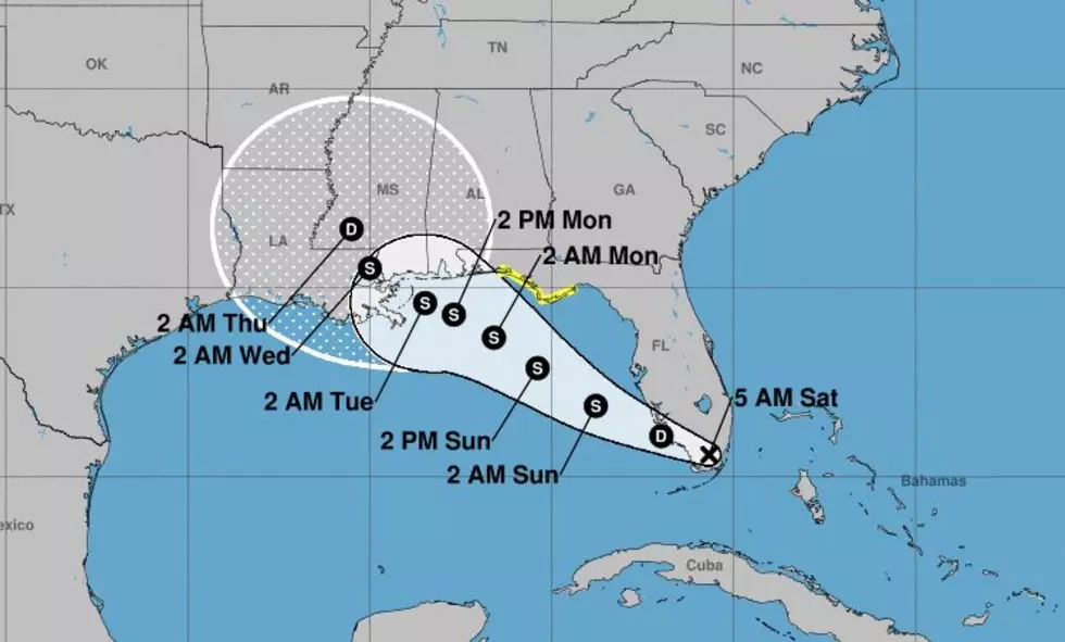
Above you can see the official forecast track from the National Hurricane Center. As you can see the "cone of uncertainty" gets very broad toward the middle of the week. So, there could be a threat from this system in Acadiana. Although, right now it does not look as if that will be the case. But things can and often do change.
Satellite images of the system do seem to indicate the storm system is getting better organized, even as it passes over land. Fortunately there is a significant amount of wind shear the system will encounter as it moves into the Gulf of Mexico. Significant enough to hopefully, keep the system from any rapid intensification over the balmy waters of the eastern Gulf.
The tropical forecast models have been in fairly good agreement on the storm's track for the next 24 to 36 hours. Beyond that time frame is where the models disagree. However, most of the guidance suggests this system will likely make landfall from the New Orleans area east to Pensacola Florida.
Just to clarify, that is not an official forecast. There have been no watches or warnings issued for those areas. However, a Tropical Storm Watch has been posted from the Ochlockonee River to Okaloosa/Walton County Line. Here's what that looks like on a map.
As of now, forecasters with the National Hurricane Center believe this system will remain below hurricane strength. However, it will be very close to that threshold at landfall late in the day on Tuesday or in the wee small hours of Wednesday morning.
It does appear as though most of the stormy weather associated with the system will be north and east of its center of circulation. If the track forecast holds this would put all of Acadiana on the "good side" of the storm. But there is a lot of uncertainty in the track forecast through time. So, stay close, we'll keep you updated.
10 Funniest Town Names in Louisiana
10 Tallest Buildings in Louisiana
More From 107 JAMZ


